REK PROJEKT OÜ

Media page and news feed
?
Aeronimeter for the creation of accurate surface models and geo-data  Aeronimeter  collects high resolution air and drone-based data, which is further processed

Advanced aerometer solutions: fast surface model processing and high-quality geometry data

Aeronimeter for the creation of accurate surface models and geo-data

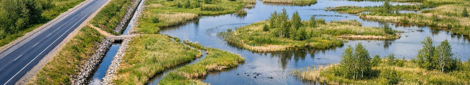
Aeronimeter collects high resolution air and drone-based data, which is further processed with a professional data processing workflow. As a result, accurate surface models, orthographs and abundant geometry data will be completed, which will provide a solid basis for design, risk assessment and land management.

What includes surface model processing and drones data processing?

The surface model processing includes data purification, point cloud generation, digital surface and soil modelling and correct alignment of coordinates to the appropriate spatial reference. Drone data processing adds precision to photogrammetry and provides a fast, cost-effective way to model complex areas.

Who is it for?

  • Building and engineering offices that need accurate surface models for design and estimation of total costs.
  • Land managers and landscape engineers looking for modern georum data for planning.
  • Li>Energy networks and infrastructure managers for which risk prevention and accurate mapping are critical.
  • Li>Environmental and groundwater analysts who need detailed landscape analysis and altitude information.
  • /l>/l>

    Mix is valuable?

    and accurate georum data reduce design errors and help to keep the budget under control. Quality surface model processing allows model-based planning, accurate cutting and volume accounting and reduces project failure risks.

    Principal characteristics and advantages

    • High precision: LIDAR and photogrammetrical results provide reliable high- and surface information models.
    • Quality control: optimised drone data processing and automated processes reduce data production time.
    • Compatible with GIS-year: finished materials suitable for popular GIS and CAD software, to easily continue design.
    • Quality control: standardised control points and metadata logs ensure traceability.
    • Attention to data purification and documentation of methods ensures that geo-data are directly available for design teams and decision makers.

      How to start

      For the start of the project, the scope of mapping, the desired level of precision and output formats are defined. A flight plan and data collection shall then be organised, followed by surface model processing, quality control and delivery of the final output. A clear workflow ensures a rapid result and reliable geo-dome data supporting the following steps.

      Reducing design, reducing risks and working based on specific data - accurate aerometering and professional surface model processing give this advantage.

Comments (0)


Are you sure you want to delete this article?

Dropdown

all articles

Land improvement design: efficient drainage solutions to increase agricultural productivity

The best start for healthy fields and lower maintenance costs    < The design of land improvement   provides a solid basis for the correct water regime, high
ssb.ee
The best start for healthy fields and lower maintenance costs < The design of land improvement provides a solid basis for the correct water regime, higher yields and lower administrative and maintenance costs in the long term. The approach is based on accurate measurement data, hydrological analysis and knowledge of local regulations to develop construction and long-term drainage solutions. For those who need accurate system design and technical support. These solutions are provided Main focus is d drainage solutions and and /strong>/strong </strong , with

Road design: building and safe solutions for forest roads, public road solutions and intersections of the state road

Design of roads  focuses on building, safety and administrative requirements of project documentation for construction and reconstruction of forest roads, priva
ssb.ee
Design of roads focuses on building, safety and administrative requirements of project documentation for construction and reconstruction of forest roads, private house access and public roads. Each solution is designed in such a way that the risks are reduced, the movement is safer and the requirements are met without repeating multiple works. Who benefits from this? The target group of the service includes a wide range of subscribers who need professional and construction-related documentation: forest and private forest management project managers who order forest roads

Licensed engineering services: land improvement design, road design and aerial metering

Full engineering and geodetic solution to ensure construction and regulatory compliance     Full engineering and geodetic solution to ensure construction and re
ssb.ee
Full engineering and geodetic solution to ensure construction and regulatory compliance Full engineering and geodetic solution to ensure construction and regulatory compliance Northern climate and Estonian regulations suitable engineering solutions combine accurate measurement data, technical design and site monitoring. Services are suitable for both public contracting entities, the private sector and agricultural and real estate developers who need a practical, durable and cost-effective approach. What service covers Aerometer - drones based and airborne data, accurate

Are you sure you want to delete this article?

Loader

Loader

App Ad

Scorestorybook Chrome extension

The Storybook extension tells you which company's website you are currently on and how reliable that company is today. download extension

See the background of the caller! Storybook App brings you direct contacts for 400,000 Estonian companies and individuals (managers, officials). The data is enriched with solvency and financial information.